25th Nov 2024
It was in October 2021, when I climbed Mount Brandon, the highest mountain in Ireland outside the Macgillycuddy’s Reeks. I had climbed Galtymore and Lugnaquilla earlier that year, soon after travel restrictions related to the Covid-19 pandemic were starting to be lifted. I subsequently made videos of these climbs, and uploaded them to Youtube. So from this the next mountain I would be climbing is Carrauntoohil, Ireland’s highest mountain.
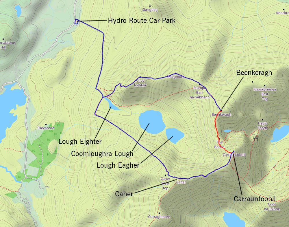
This is not the first time I climbed Carrauntoohil. That was back in 2001. The route I took then was the Coomloughra loop, to the west. Back then, all I had to rely on was an Ordnance Survey map, 1:50,000 scale, as well as a compass. No GPS devices.
Ad by Google
Since the climb of Mount Brandon in 2021, I climbed Carrauntoohil a few times (in September 2022 and September 2023) and, although I reached the top, some aspects associated with making the video didn’t work out. To cut a long story short, the climbs took longer than I had expected, many of the shots I had taken didn’t work out the way I had hoped, and I didn’t arrive back at Cronin’s Yard until after dark. Fortunately I had a torch on me on these occasions, and I was able to make it back safely.

Since the clocks went forward this year at the end of March, I was keeping an eye on the forecast, specifically mountain-forecast.com, for weather conditions at the summit of Carrauntoohil. Almost every weekend, it was more or less the same story – no clear skies over Carrauntoohil on Saturday. Without clear skies, I felt there was no point travelling down there. That said, I didn’t mind there being a sprinkling of clouds.
Eventually, on the last weekend of July, there was hope that I would get favourable weather conditions for a climb. And so, on the 26th July, I decided to head down to Cronin’s Yard directly from work on the Friday evening, and camp there for the night, and start the climb on Saturday morning.
Ad by Google
Although it rained for most of the night, I was hoping that it would clear up by the time I reached the summit. On the Saturday morning, there were several things to do before starting the climb, including having breakfast, dismantling the tent, packing it up and putting it into the car, and doing the intro clip for the video.

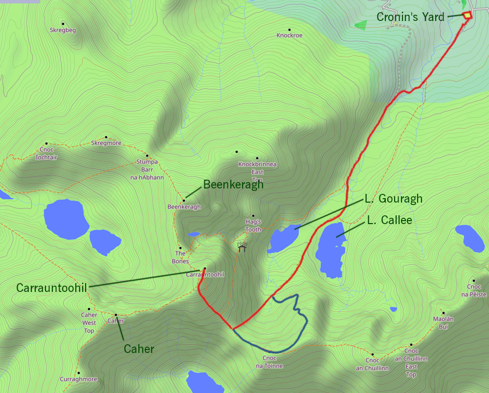
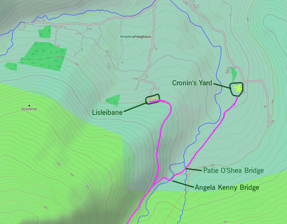
Finally, at around 7:45, it was time to leave Cronin’s Yard, and head towards Carrauntoohil. I have an app on my phone, called “GPS Hiker”, which shows me on a map, where I was. With this app, I took a screenshot with my phone whenever I passed certain key points along the way, and each screenshot recorded exactly where I was, and what time it was at each point:
- 7:46 Leaving Cronin’s Yard
- 8:05 Crossing the Patie O’Shea Bridge
- 8:09 Crossing the Angela Kenny Bridge
- 8:14 Passing the junction between the path from Cronin’s Yard and that from the car park at Lisleibane
- 8:34 Crossing the Stepping Stones
- 8:43 Starting to pass Lough Callee
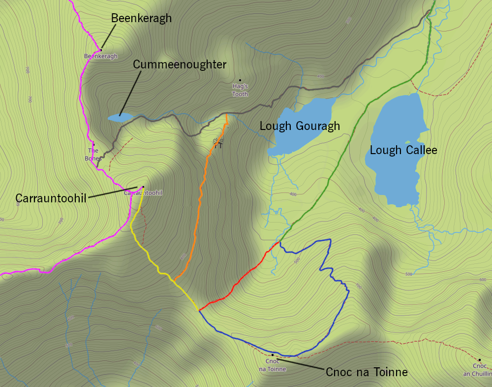
- 9:24 At the bottom of the Devil’s Ladder
- 10:43 Reaching the top of the Devil’s Ladder
- 10:59 Resumed the climb
- 11:57 Reached the summit
From Cronin’s Yard to Hag’s Glen is typically uneventful. It was after passing between Loughs Gouragh and Callee, that I decided to take out the trekking poles. From there, the gradient slowly but surely gets steeper. Then I reached a point on the Devil’s Ladder where it was better to just stow away the trekking poles and just use my hands to grab onto the rocks and boulders.

Finally, I reached the top of the Devil’s Ladder. I decided to take a break, take some refreshments before going the rest of the way to the summit.
Ad by Google
Just before 12:00, I reached the summit of Carrauntoohil. It was then that the clouds started clearing from the summit. There were quite a few other people there when I arrived, probably taking advantage of the clear skies, an occurrence that seems to be getting rarer each year. Carrauntoohil is another of these summits where you have to walk around to see more of the landscape. You can’t stay in the vicinity of the cross at the summit and expect to see everything. I spent the next hour and a half or so taking images of the surrounding peaks, as well as video clips panning around from near the summit. This includes having to go halfway between Carrauntoohil and Caher, an altitude of just under 900m, compared to 1038m at Carrauntoohil, to get a shot of the three lakes in the Coomloughra Valley – Lough Eighter, Coomloughra Lough and Lough Eagher.

It was 1.45pm that I started to make my way back down. I decided that my descent would not be by the Devil’s Ladder, but up to Cnoc na Toinne, and then the Zig-Zags, then onto the Hag’s Glen on the route back to Cronin’s Yard. With this route, after passing the top of the Devil’s Ladder (720m), there is a climb up to the top of Cnoc na Toinne (845m), after which there is a short distance of nearly level path, before reaching a small cairn, which marks the top of the Zig-Zags. It is possible to see this path from the summit of Carrauntoohil; I counted 15 switchbacks on the way down to Hag’s Glen. Once back on the route leading to the Devil’s Ladder, there was still some descending before reaching the pathway between Loughs Gouragh and Callee, and then back to Cronin’s Yard.
Back at Cronin’s Yard, I recorded the outro clip for the video, before heading to Killarney, where I went for a walk around the town, including swinging by Peter Cox’s (a landscape photographer) shop on Plunkett Street, and then going for a meal before heading home.
I decided to edit the video for this outing using Blender, which is an open-source program for 3D modelling, but also sculpting, VFX and video editing. Previously I used Nero Video Editor. I found that there are many things I can do with Blender that are not so easy to do on Nero. However, the one thing that Blender was lacking as opposed to Nero is the choice of transitions – how the video changes from one video clip into the next. There are only three types of transition available, which leaves a lot to be desired, and although there is content online which shows you how you can define your own transitions in Blender, I would consider them to be “workarounds” at best. I am just hoping that in future versions, they will provide additional transition styles, and instruction on how to make your own transition styles.
Could I see myself going back there to climb Carrauntoohil? I suspect, not if those around me have their way. Firstly, age is starting to go against me. I recently turned fifty. That said, I’m sure I wasn’t the oldest person on that mountain that day. Secondly, although I didn’t mention this in my Youtube video, and I rarely talk about anything medical on social media, I have had quite a scare in March 2023 and, to cut a long story short, I now have a cardiac pacemaker. And then in October that year, I underwent surgery for an unrelated condition.
There are loads of photo opportunities that present themselves around the Macgillycuddy’s Reeks, even without doing any of the big climbs, for example, the several lakes around the mountain, as well as streams and waterfalls, which present excellent photo opportunities for images with Carrauntoohil in the background.