2nd Aug 2021
It was in mid June, when I decided to climb the highest mountain in Leinster, namely Lugnaquilla, in County Wicklow. Easing of restrictions imposed due to the pandemic meant that for the first time this year, inter-county travel was permitted.
Lugnaquilla has the third-highest prominence in Ireland, with a height of 925 metres. It is not the third highest mountain; there are other peaks besides Carrauntoohil and Mount Brandon, that are higher.
Ad by Google
There are three popular routes up to the summit. Two of these are from the east of Lug. The first starts from the Baravore Car Park (GPS 52.988050, -6.412869). It crosses the Avonbeg river, then goes through a forest track, then Fraughan Rock Glen, before the steepest part of the climb, running more or less along the Fraughan Waterfall. You will finally reach a plateau, the worst of the climb behind you, before the route turns south towards the summit.
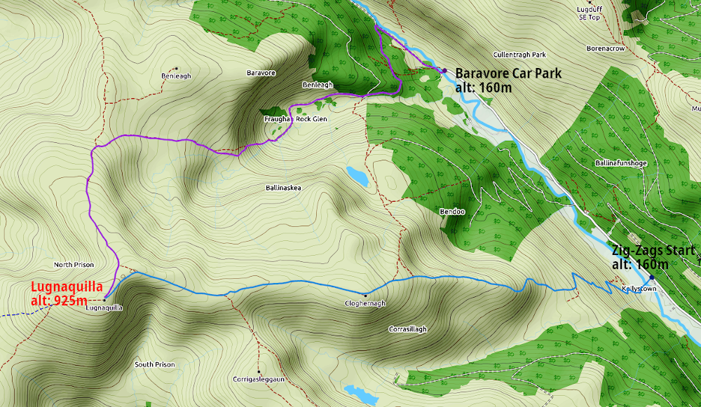
The second route, approaching from the east, is known as the Zig-Zags. This route starts near the Carraway Stick Waterfall (GPS 52.969196, -6.381653). This route starts with a switchback path from the valley, until one reaches Cloghernagh (approx. 790m), from where there is a relatively gentle incline the rest of the way to the summit.
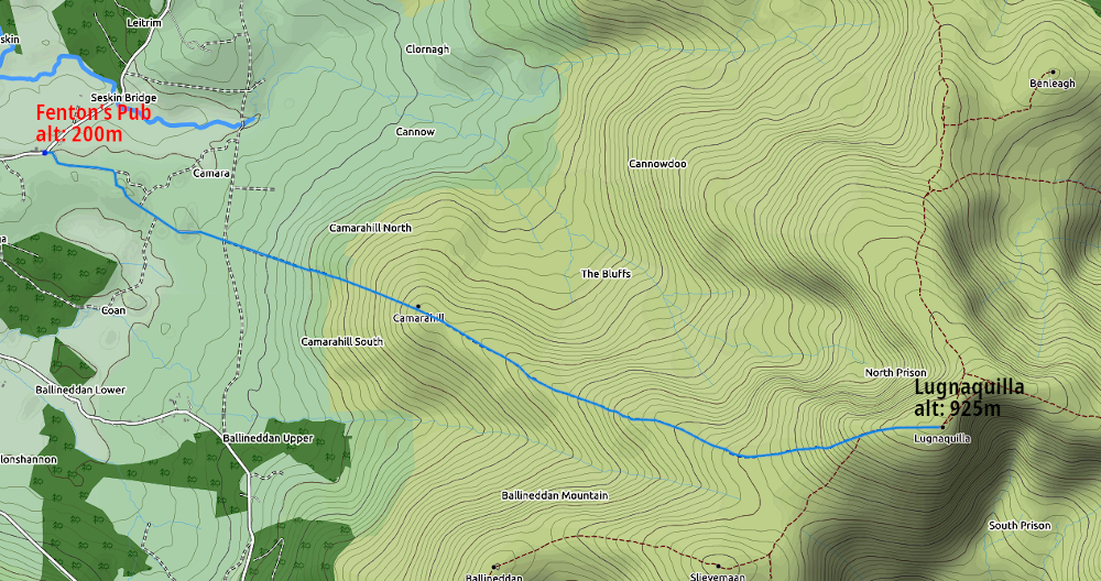
The third route, which many call the shortest and easiest route to the summit of Lug. One small problem – it goes through the Glen of Imaal, which is used on weekdays by the Defence Forces for live firing exercises, during which time this route is off limits to the public. The route starts at a car park next to Fenton’s Pub (GPS 52.983972, -6.552392). From there. It passes Camara Hill, along a fairly straight path to the summit.
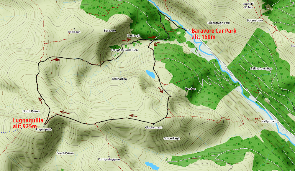
The route I took was a combination of the two routes from the east, i.e. from Baravore and from the Zig-Zags.
I parked at the Baravore Car Park, from where I went up through the forest trail, passing Glenmalure Hostel, a short distance from the car park. This is a small youth hostel that doesn’t have running water or electricity.
Once the path emerges from the forest, and into Fraughan Rock Glen, I head off the laneway, across a stream, then up a rather steep incline towards Art’s Lough. From there, I continued up the incline, towards the Zig-Zag route, towards Cloghernagh.
Once I reached Cloghernagh, the hard part of the climb was done. From there, I could see the summit of Lugnaquilla, and it was a relatively gentle ascent the rest of the way. Nearer to the summit, there was a cwm on each side of the pathway – the South Prison on the left, and the Green Corner to the right. From that spot, it is clear where to go to reach the summit: keep going forward and then hang a left, and the stone cairn is easy to see from a few hundred metres.
Ad by Google
On the day I climbed the mountain, there was what could be described as a gale coming up from the South Prison. It is often said that a gentle breeze near the foot of the mountain is often a gale near the summit.
It seems to be something of a ritual when climbing a mountain, to reach the summit, touch the cross or, if there is none, touch the triangulation pillar. And then one can take out some refreshments, or in this case, walk around the plateau to see what’s around.
Now this plateau is approximately 300m long and 150m wide, so a considerable amount of walking around is necessary, in order to see as much of the surrounding landscape as you can from the summit.
What or how much you will see from the summit depends on how much cloud cover is there, but also if the sky is hazy. With ideal conditions, you should be able to see the Irish Sea to the east, although if you look north, all you will get to see is more of the Wicklow Mountains. Glendalough is not too far north of Lug, not that you will be able to see these lakes.
To the west, all you will see is plains of Counties Kildare and Carlow, for the most part. There is a rather notable mountain more or less to the south, which I think is Mount Leinster (height 794m).
I reckon it was a little over an hour from when I arrived at the summit, before I began the descent.
My way down was through Fraughan Glen. Initially after leaving the summit, one heads due north for a few hundred metres, before turning east. This part of the descent calls for choosing your route down carefully, with different parts of the descent having different reasons for this.
At first, the ground is not so steep, but it is soft in a lot of places, so one needn’t be surprised to find oneself backtracking at times. Eventually soft ground will give way to a steeper descent, which fortunately is firmer, so as long as you have the right footwear, and you take it easy going down, you shouldn’t have much problems.
Ad by Google
There is a waterfall that runs down the glen, which I was hoping to get some still long exposure shots of on the way down, but I was struggling to find a good composition. However, there are a few points along this waterfall, that you could just sit next to it, and listen to the water coming down all day; it seems small to medium waterfalls tend to have something of a calming effect.
Finally the steeper descent will give way to a track that is level or, at worst, a relatively easy gradient.
It was early even when I finally arrived back at the car park. There were fewer people around then, than in the morning when I arrived to begin my climb. I set up my equipment to do what I call the “outro”, which goes near the end of my YouTube video. After that, I pack up my equipment, a change of clothes, some refreshments, and then start the journey home.
On driving along the Glen Road after leaving the car park, there were a considerable amount of vehicles – not just cars, but also quite a few camper vans and motorcycles, parked along that road, before I reached Glenmalure.
Could I see myself returning to this neck of the woods? Probably yes, even if not to climb to the summit of Lugnaquilla again. Although one thing that makes me wary of a return journey is the quality of roads in that area, I mean narrow, twisty, steep, or some combinations of these adjectives to necessitate reducing my speed to not much more than a crawl.
All that said, I probably should say I was rather fortunate with the weather I had on the day, that it was dry, albeit very warm, with the mercury in the mid 20s. Had it been cloudy, with fog coming in over the mountains, as can happen from time to time, it would have been a completely different story. When this happens, it can be very easy to get disoriented without the right tools and knowledge to help you know where you are, at all times.